We were appointed by our developer client as landscape architects on this proposed mixed use (commercial and residential) development located in east London. We were tasked with the production of a landscape design to the satisfaction of our client, then to develop a landscape architect’s package of information to support a detailed Planning application. This included the production of a landscape architect’s design statement which explained our landscape design in detail.
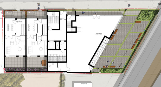
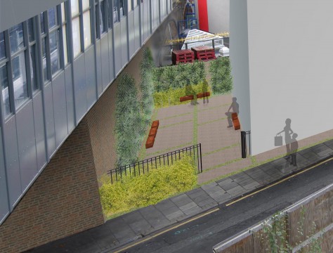
The proposed built form is located tight up against the plot boundary on all sides apart from the elevation facing the Docklands Light Railway (DLR). Our landscape architects suggested small courtyard space in this location due to building constraints imposed by the DLR. Our landscape design suggested that this space be simply paved with coloured bands of brick pavers reflecting the banding found in the elevation of the building. The south part of this space is located under the overhang of the DLR platform above. In these locations galvanised arched trellis’ were proposed, these mimic the arches found on the structure of the viaduct. The trellis’ were proposed to be planted with shade tolerant planting and is to be up lit at night. It was envisaged that this space would occasionally be used by the occupants of the commercial unit and it was intended that it will look attractive when not in use at night.
The general strategy adopted for the drainage of this site was that of Sustainable Urban Drainage Systems (SUDS). Permeable block pavers were proposed and excessive rain was to be accommodated in the planted areas.
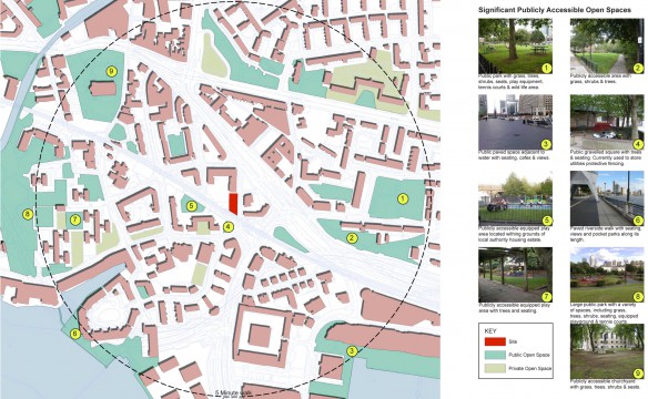
In addition, we were commissioned by our client to carry out an Open Space Assessment. The target area was inside a radius of five minute walk from the site. We identified all publicly accessible space and private open spaces. These were then mapped with our site at the centre.
The Open Space Assessment was then used by the design team to inform if there was need for open space within the vicinity of this development and if there was what type should it have been. This information then formed part of the planning submission for this site.
Landscape Institutes Work Stages: C to D
Client: Noble House Properties
Architect: StockWool